Satellites hovering hundreds of miles above earth; underwater autonomous vehicles traveling through the ocean; drones collecting snot above whales; and robots that move like fish; what do all of these things have in common (other than sounding like some futuristic world where robots and computers have completely taken over)?? Turns out, all of these things are tools scientists use, today, to help measure the health of our oceans, take samples in remote and often inaccessible places, or observe animal and fish behavior in as un-obtrusive way as possible. They are ways that technology merges with science to allow us to collect a lot of data with (somewhat) less effort.
A lot of these techniques allow scientists to be removed from the data collection: either as being away from where the samples are being taken (as, cozy in a warm room on land while an underwater autonomous vehicle takes samples thousands of miles in the middle of the ocean) or allows for continuous data collection (as in satellites constantly taking measurements of earth from space). No matter how far away the scientist is, it’s a way for us to get valuable data that we wouldn’t otherwise get by just going out into the field and observing what’s happening directly. The motivation for this blog post came from a recent article at NPR that talked about a new robot fish. I’ll describe a few of the different ways technology is being used in science and talk about how scientists are using them to check-out what’s happening in the environment!
- Robot Fish (really called, SoFi) – This thing is crazy. It actually moves like a fish through the water (while being controlled remotely by a nearby diver). The researchers and developers are using SoFi (which has built in cameras) to monitor fish behavior in the ‘natural’ environment. Think about it: as soon as a scientist goes diving down into a reef or lowers a camera from a boat, the environment (and therefore the behavior of the fish) has changed. This makes it nearly impossible to use these techniques to accurately capture how fish behave in the environment. That’s where SoFi comes in: because it mimics the movement of a fish, it will alter the environment (and other fish’s behavior) less, allowing scientists to really see how these organisms interact with other fish and the environment naturally! Right now it has to be remotely operated by a diver in the water, but researchers hope it can be used one day completely remotely.

All kinds of sensors can be put on drones to remotely monitor the environment, including cameras. Image from here.
- Drones – since the robot fish is basically an underwater drone, we’ll talk about drones next. There’s a great article by fellow UNdertheC blogger, Shelby, on the use of drones to collect whale snot, but drones can be used for a lot of other things too. This can include things like population counts. Drones can be (quietly) flown over a colony of animals, snapping pictures, and counting the number of animals. This allows scientists to quickly, efficiently, and as sneakily as possible, count the number of animals in a given area, whether this is on land or in the ocean.

A deep water AUV that’s used to dive to depths that humans can’t survive. Like drones, all kinds of sensors can be attached. Image from here.
- Autonomous Underwater Vehicles (AUV’s) – moving up in scale a little bit, AUV’s, are essentially really large drones guided by satellites and can be used to dive really, really deep or travel for really, really far distances in the ocean. AUV’s can also be loaded with sensors that allow scientists to remotely measure everything from temperature and salinity to things like how much phytoplankton are in the water and even what kind of phytoplankton are there. They can also carry cameras to allow scientists to see what’s happening at depths that are too deep for any human to go.
- Satellites – this brings us to the remote sensing technique that can see the entire Earth in one day (and the technology that has been around the longest). Using sensors rocketed up into space on satellites, scientists can measure everything from temperature, salinity, estimate the amount of phytoplankton, the amount of organic matter, and the height of the sea surface for the entire Earth, all based on the amount (and type) of light reflected off of earth and to the satellite. This allows for a really big picture of exactly what’s going on in the oceans all over the world. And while this works really, really well on the big picture scale, if you want to see what’s happening on a river by river scale, then things start to get a little bit more difficult. Satellites are all about the big scale (at least for now)!
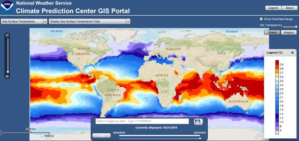
A screenshot of the Sea Surface Temperature interface from NOAA. You can clearly see that the southern hemisphere is in the summer (much warmer temperatures!) and the northern hemisphere is still in winter (much cooler temperatures!). You can play around with the interface here.
Technology is always evolving (think about how much better your new cell phone takes pictures!) and that is certainly true of the technology used in science. As funding becomes tighter and as scientists ask for more information, technology, like the ones described above, will become ever more prevalent. But don’t worry! Even as we put more robots in the ocean, there will still be plenty of data analysis and problems to solve, for us scientists!
Lots of cool technology, comes from lots of different places. A list of some good resources (and labs) using this technology are below:
The MIT lab that developed SoFi
